Director’s Note: Initial findings, post-Ian
Over the weekend, I spent time down in North Port with a friend, delivering gasoline and water to folks who didn’t or couldn’t leave their houses. While out there (in my dinghy) we noticed failed septic tanks, porta potties tipped over and submerged in floodwaters, as well as loads of submerged cars and trucks. Dead animals were in the flood waters – and over 200 dairy cows died in the flooded Myakka River. We have wastewater overflows all over our watershed – raw sewage spilling out via flooded collection systems and pump station failures (which often co-occur). In short, our water quality is a mess right now, with impacts worse in the lower bay than the upper bay.
In response, we worked with staff from Charlotte County, the Coastal and Heartland National Estuary Partnership (CHNEP), the Florida Fish and Wildlife Conservation Commission (FFWCC), the Southwest Florida Water Management District (SWFWMD), Environmental Science Associates (ESA) and Benchmark Laboratories to design a monitoring program that would measure the human health risks associated with impacts from Hurricane Ian, as well as the impacts to the health of Sarasota Bay, Lemon Bay, Charlotte Harbor, and the Peace and Myakka River watersheds. We went from discussions about how to design such a program, what parameters should be collected, how often we should sample, where we should sample, etc. to actual implementation in three days. Yesterday we implemented a monitoring effort that we’d only started to think about designing on Sunday. A big shout out to the handful of people who helped to get this done so quickly.
In Sarasota Bay, the SWFWMD provided the boat and staff (Chris Anastasiou and Mark Walton) to assist Jay and myself. We sampled nine sites from Venice Inlet up to Siesta Drive. At those locations, we sampled the water column for temperature and salinity and oxygen levels, and also took samples back to a laboratory to analyze levels of bacteria in the water, the amount of nutrients, and the amount of organic matter that can build up and cause later problems with oxygen. We won’t have the laboratory results back for a few days still, but we do have “field data” already. The two below pictures show drone footage of southern Blackburn Bay prior to (August of 2022) and after (this past weekend) the passage of Hurricane Ian. The photos are strikingly different, but what do they indicate is happening out there?
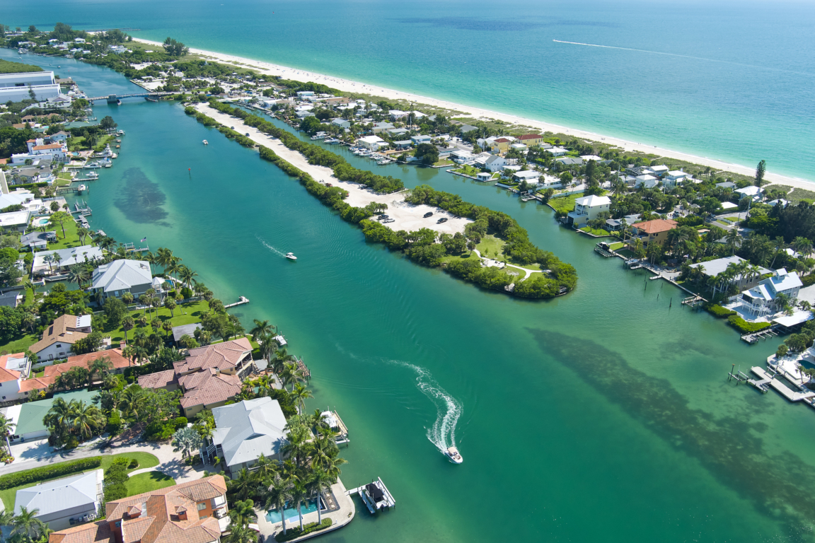
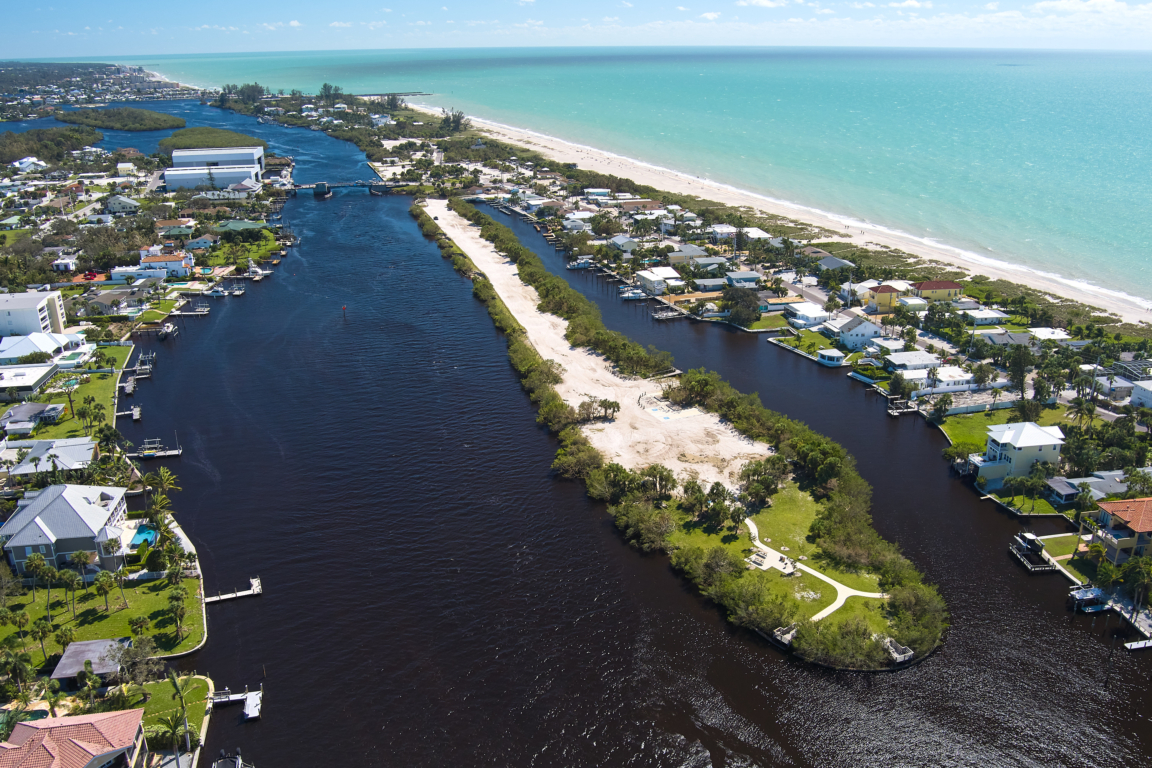
As you can see from the two photos, water quality has changed dramatically, in response to Ian, particularly in the lower bay. The second picture looks “bad” to most people, but what we’re really interested in is what exactly is in the water, not just what it looks like. First off, most of the difference between these two pictures is due to tannins – the same stuff that stains swamp waters and that makes iced tea actually look a lot like swamp water. Tannins are classes of compounds that come from decomposing plant matter. They are water soluble, and thus don’t “settle out” the way that sand or silt does. If you see the satellite images of Southwest Florida that are on social media, those aren’t plumes of turbidity from sediment, they are mostly tannin-rich water. And, as we found out yesterday, those plumes are actually restricted to the top five-feet or so of the water column – because they represent a plume of low density and tannin-rich water floating across the top of higher density and low-tannin salt water.
We don’t have the bacteria data yet, but in 2004, most of the “fecal indicator bacteria” in the Peace River were actually due to decomposing vegetation, made worse by sewage spills and dead animals, certainly. But the best indicator of low oxygen and high bacteria was not how many houses you had in the sub-basin, or how much agriculture, but how close was the sampling location to the eyewall of the hurricane. We expect to see some version of that here, after Ian.
Based on yesterday’s results, the only problems we had – so far – with oxygen was in the bottom of the water in Little Sarasota Bay and southern Roberts Bay. That only happened when we had what is called salinity stratification – when there was so much freshwater inflow that the less dense freshwater formed a lens of sorts on top of the denser seawater. In those two areas, we found surface salinities of about 8 to 10 ppt, while the bottom was about 25 ppt. With such a strong salinity and density gradient, the water on the bottom becomes “isolated” from getting oxygen from the atmosphere, and it is too dark for algae to photosynthesize. That means the bottom water will consume more oxygen via respiration than it will produce via photosynthesis, while being isolated from oxygenation from the atmosphere. When that low oxygen water (aka hypoxia) develops, larger fish will simply swim away. But clams and worms and smaller fish may succumb and die-off.
The pictures above from Blackburn Bay represent what your neighbors are seeing, and it doesn’t look great. But water that looks like this doesn’t mean the bay’s health is at serious risk of collapse. Again with the dog analogy – your dog won’t die if you forget to feed it a few days in a row, but it will die if you don’t feed it enough over the course of weeks to months to years. A healthy Sarasota Bay will be able to recover from the impacts of Hurricane Ian, if the impacts work through our system over a period of one or two weeks or so. But the bay’s water quality and ecological health is not up to the task of accommodating years on end of impacts from wastewater overflows and urban stormwater runoff and damage to our fringing mangroves. In 2021, we had the best water quality – across the bay – in the last 5 to 15 years (depending on location). That improvement was made possible via the combination of stormwater retrofits, habitat restoration efforts, and upgrades to our wastewater infrastructure. Because we were healthier in 2021 and in the first months of 2022, we are better able to handle the impacts of Hurricane Ian than we would have been five or ten years ago.
A healthier bay is a more resilient bay. And since storms such as Ian are more likely over the next 20 years than they were the last 20 years, staying as healthy as we can will be even more important in the future as it is now. We’ll let you know when we get our lab results in.
One last thing – I wanted to give a big shout out to a couple of people who helped to plan and implement the rapid response water quality sampling effort we’ve already begun to implement. This list includes Brandon Moody (Charlotte County), Chris Anastasiou (SWFWMD), Emily Keenan and Bob Woithe (ESA), Dale Dixon (Benchmark Laboratories), and Nicole Iadevaia (CHNEP). They and others, including myself and Jay Leverone, then implemented the monitoring program that we had designed. My thanks go out to those who worked over the weekend not only to help clean up their own houses and neighborhoods, but took the time to do this important work as well.