Seagrass & Algae
Seagrass and macroalgae (i.e. seaweed) are important for thriving estuaries. They also act as indicators for determining the overall health of Sarasota Bay. Every year, SBEP relies on partners and citizen scientists to help gather data about these indicators through the Eyes on Seagrass Program and other statewide monitoring efforts. Results are then compiled into the Sarasota Bay Ecosystem Health Report Card, which offers a snapshot of how our bay is doing.
Seagrass in Sarasota Bay
Seagrasses are flowering plants that live in the shallow waters of estuaries and lagoons. There are seven distinct seagrass species found on the Southwest Florida Gulf Coast. However, most seagrass meadows are dominated by three species:
Turtle Grass - wide, flat blades
Thalassia testudinum

Credit: SBEP
Manatee Grass - round blades
Syringodium filiforme

Credit: James St. John, Creative Commons Attribution 2.0
Shoal Grass - thin, flat blades
Halodule wrightii

Credit: Hans Hillewaert, Creative Commons Attribution-Share Alike 4.0
Invasive Seagrass Species Observed in Biscayne Bay in 2024: Halophila stipulacea
The Florida Fish and Wildlife Conservaiton Commission released an advisory for a new invasive species. It is currently only found in southeast Florida, but they would like people to be aware and report any findings - Learn more.
Why Are Seagrasses Important?
Seagrasses provide numerous benefits to marine critters and to people:
- They support the local economy around water-based tourism.
- Their roots can help stabilize the seafloor and prevent erosion.
- They help filter water by capturing sediment and pollutants.
- They store carbon and are considered a blue carbon source to help reduce the effects of climate change. In fact, one acre of seagrass can offset the carbon emissions of one automobile.
- They release oxygen into the water and atmosphere
- They provide habitat for numerous commercial and recreational fish, shellfish, crabs, shrimp, sea cucumbers, sponges, and worms. About 70% of the recreationally and commercially important species spend a part of their lives in seagrasses. These meadows are considered important nurseries. According to researchers at Florida Atlantic University, there are approximately 40,000 fish found in the average acre of seagrass.
- They provide food for turtles and manatees. In fact, the high mortality rate of manatees in the early 2020s on the east coast of Florida was mainly due to starvation from the loss of seagrass.
- Algae and other small organisms (called epiphytes) that settle on seagrass blades provide food for fish, crustaceans, and invertebrates.
What Do Seagrasses Mean for Water Quality?
The extent of seagrass in Sarasota Bay is a good biological indicator of water quality. Clearer water with less algae means sunlight can reach deeper depths, allowing seagrasses to expand into deeper water.
How is Our Seagrass Doing?
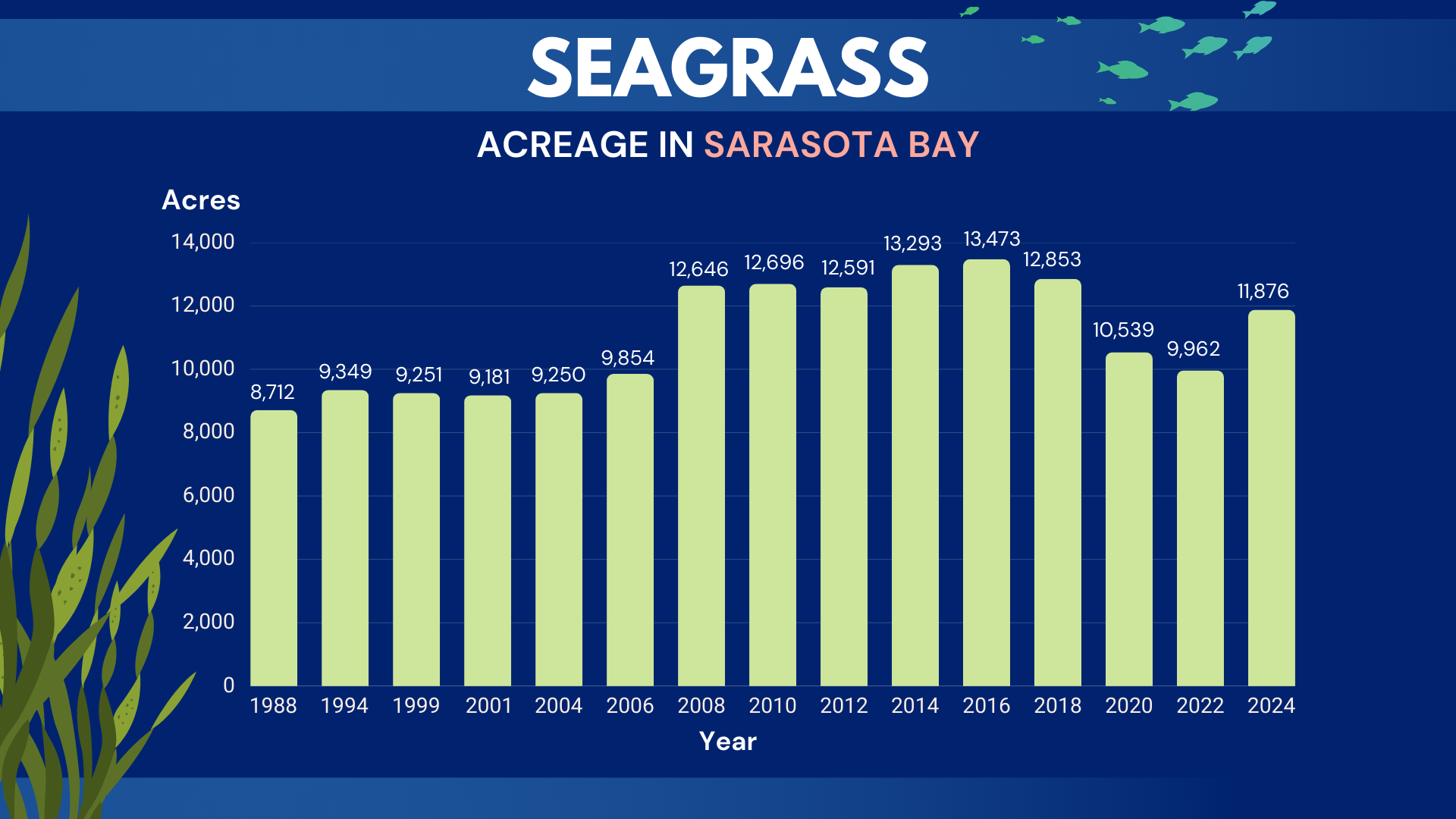
Every two years, the Southwest Florida Water Management District maps seagrasses acreage in Sarasota Bay using aerial photography. In 2024, the Southwest Florida Water Management District mapped 11,876 acres of seagrass throughout all five bay segments of Sarasota Bay. This is 19% (1,913 acres) more than what the bay had in 2022 and 36% (3,161 acres) more than what the bay had when the mapping program began in 1988. However, it is still 1,597 acres less than the highest seagrass acreage the bay had in 2016. All bay segments showed an increase from 2022 with upper Sarasota Bay near Longbar Point showing the largest gains.
2024 Seagrass Acreage

2024 Gains and Losses

Want a closer look? Explore SWFWMD's Seagrass Maps for Sarasota Bay.
Why Did We See More Seagrass in 2024?
More seagrass generally means that water quality is improving. These recent increases are likely due to specific management actions that improved water quality over the last couple years, like upgrading wastewater and stormwater treatment infrastructure as well as informing the public about ways to reduce pollution. The seagrass increases for Sarasota Bay did not come from transplanting seagrass or from drought (which would reduce the amount of stormwater and nutrient pollution flowing into the bay).
Better Water Quality Supports More Seagrass
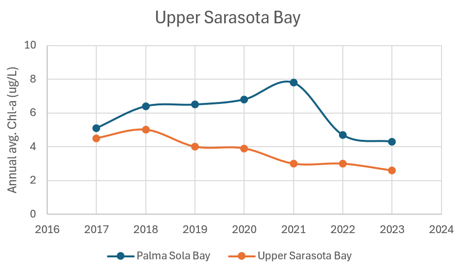
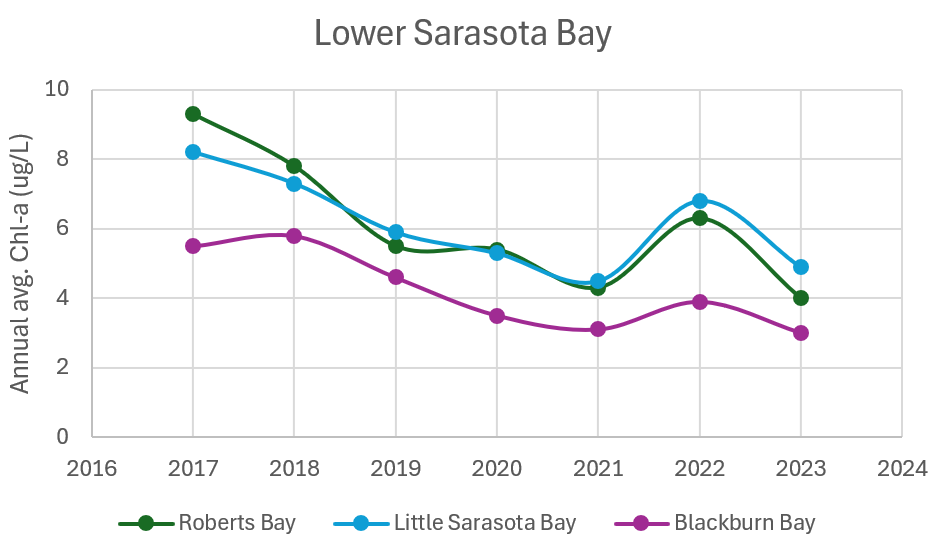
The graphs below show improving water quality over time by tracking one of the bay health indicators: chlorophyll-a. Chlorophyll-a indicates how much algae is in the water. Like most things, some algae is good, but too much can cause problems. In these graphs, all bay segments are showing decreasing trends in chlorophyll-a, or algae. In relation to seagrass, less algae allows more sunlight to reach deeper depths and increase seagrass meadows.
What About all the Storms in 2024?
It is important to note that the seagrass maps for 2024 were photographed BEFORE our coast went through Debby, Helene, and Milton. From photo to finished map, the whole seagrass mapping process takes about a year because the Southwest Florida Water Management District has robust methodology to ensure accuracy in the final seagrass numbers. This includes a rigorous quality control process for every photo prior to being released to photo interpreters, and site visits to more than 1,000 points across the region to ground truth the accuracy of the photos.
While the impacts of the 2024 storms will continue to be monitored, staff from the Southwest Florida Water Management District and SBEP visited Upper Sarasota Bay in the spring of 2025 to view the area's largest acreage increase. It appeared that last year’s severe weather events did not significantly impact the seagrass in those recovered areas.
To read more about water quality in Sarasota Bay, check our Ecosystem Health Report Card
Macroalgae in Sarasota Bay

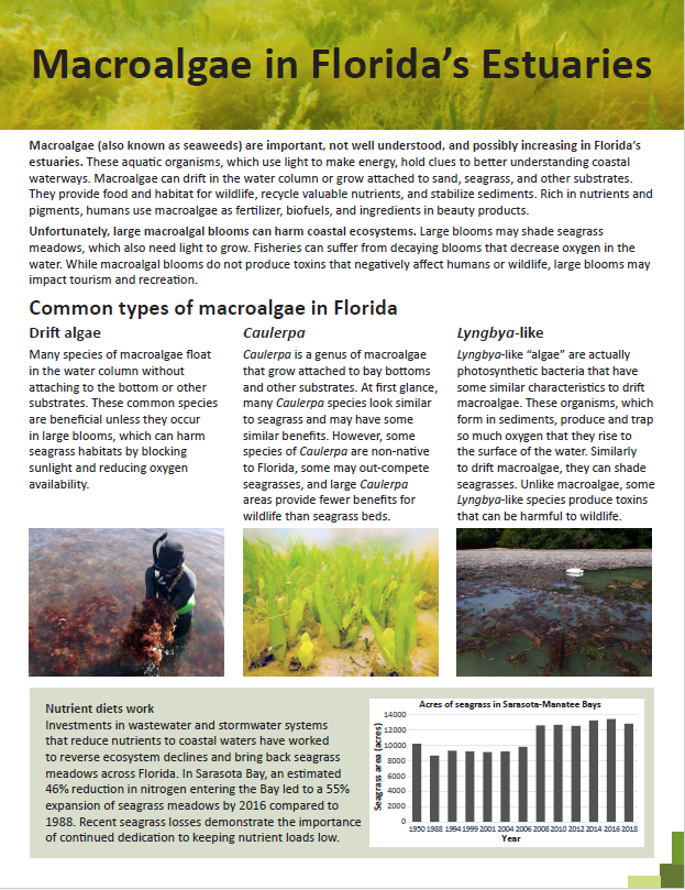
Macroalgae: or seaweeds, are important food and habitat for estuarine creatures. However, they can respond quickly to nutrient pollution by growing and shading out seagrass meadows. Plus, the bacteria that break down macroalgae blooms can reduce oxygen levels in the water, which is dangerous for fish and other wildlife. Therefore, large macroalgae blooms are an indicator of poor water quality.

Eyes on Seagrass Macroalgae Monitoring
The Eyes on Seagrass Program is a bi-annual event in partnership with Florida Sea Grant, Mote Marine Laboratory, and Sarasota and Manatee counties to measure macroalgae and seagrass coverage. The program was expanded from Charlotte Harbor to cover Sarasota Bay in 2021 in response to a data gap in macroalgae monitoring. During a two-week window in April and July, participants snorkel to various locations throughout Sarasota Bay to survey and collect information on seagrass and macroalgae coverage. Results are integrated into Sarasota Bay Ecosystem Health Report Card.

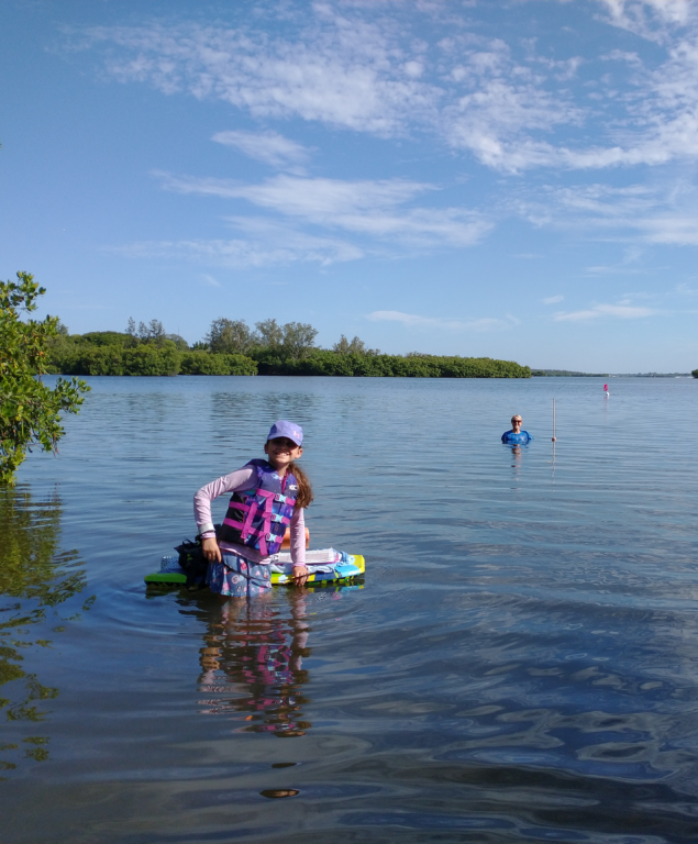
Eyes on Seagrass Macroalgae Results (2025)
Summary
Macroalgal coverage decreased in four of five bay segments, with Roberts Bay showing a significant increase, likely due to altered flow patterns following the opening of Midnight Pass. Seagrass coverage increased in three of five bay segments, was stable in a fourth, and showed a slight decline in the fifth bay segment during the sampling period. These trends suggest that, overall, our bay system demonstrated resilience, withstanding the multiple extreme and historic 100-year weather events of 2024 without showing the degradation observed during less severe events in the past.
Recent Bay Conditions
The 2025 sampling season began following the highly impactful hurricanes and storms of 2024. These events brought multiple 100-year flooding occurrences, record-setting rainfall across the watershed, two storm surge events, and significant overwash of sand from beach to bay, which buried some seagrass beds. Notably, Midnight Pass opened twice, dramatically altering the hydrology of Little Sarasota Bay.
Any one of these events would be considered extreme for our region. The reopening of Midnight Pass shifted flow patterns in Little Sarasota Bay from a 27% turnover rate over 10 days to an estimated 70% turnover in the same period. This change has significantly altered the bay’s salinity regime, transitioning it from a polyhaline (18–30 PSU) to a euhaline (30+ PSU) profile, now heavily influenced by Gulf waters. These shifts are reflected in the flushing and salinity models developed for the Little Sarasota Bay Watershed Management Plan.
Macroalgal Coverage
Results from the two 2025 EOS sampling periods (Spring and Summer) show the expected seasonal decline in macroalgal coverage (Figure 1):
- Palma Sola Bay: 29% → 16%
- Sarasota Bay: 49% → 14%
- Little Sarasota Bay: 35% → 2%
- Blackburn Bay: 45% → 1%
The exception was Roberts Bay, where coverage increased from 18% in winter to 40% in summer. Two sites recorded high biomass levels of 430g and 750g per quadrat, with one site having no seagrass along the transect. This more than doubling of macroalgal cover in Roberts Bay may be linked to changes in flow and salinity resulting from the opening of Midnight Pass (see flushing and salinity models). Continued monitoring of Roberts Bay is necessary to determine if the abundance of macroalgae will continue to increase. Additionally, in the lower bays—particularly lower Little Sarasota and Blackburn Bays—heavy fouling of seagrass blades by Dapis was documented. This level of fouling is likely driven by watershed runoff, inflow into Donna and Roberts Bay, and elevated summer temperatures.

Seagrass Coverage
Results from the 2025 EOS sampling periods (Spring and Summer) show the expected seasonal increase in seagrass coverage (See Figure 2) in the following bays:
- Palma Sola Bay: 44% → 51%
- Roberts Bay: 17% → 46%
- Little Sarasota Bay: 12% → 45%
Slight decreases were observed in:
- Sarasota Bay: 60% → 59%
- Blackburn Bay: 52% → 48%
However, due to limited sample sizes and variation in sampling sites, these changes fall within a wide margin of error. When viewed in the context of long-term trends, both Sarasota and Blackburn Bays appear to be within the range of expected summer coverage observed in previous years.
These data suggest that the system-wide impacts of multiple extreme weather events in 2024 may not have caused lasting damage to the growth of seagrass meadows. Instead, the meadows appear to be following normal seasonal growth patterns or remain stable compared to previous sampling seasons. The upcoming SWFWMD aerial surveys will provide the most comprehensive assessment of the current condition of our seagrass resources.

Learn More
References
Reynolds, P.L., Duffy, E., Knowlton, N. (2018). Seagrass and seagrass beds. Ocean Portal. 16(10).
Florida Fish and Wildlife Conservation Commission. (2025). Manatee Mortality Statistics. https://myfwc.com/research/manatee/rescue-mortality-response/statistics/mortality/.
Southwest Florida Water Management District. 2025. Sarasota Bay Estuary Seagrass Mapping.