Director’s Note: More info on Ian
We may be seeing a bit of a good news / bad news scenario playing out, in response to Hurricane Ian.
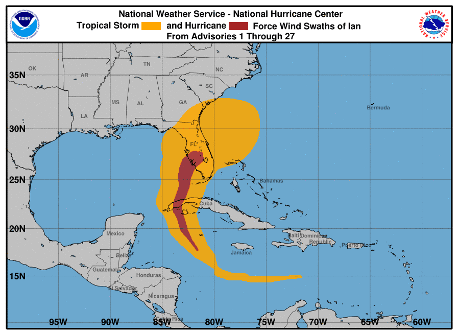
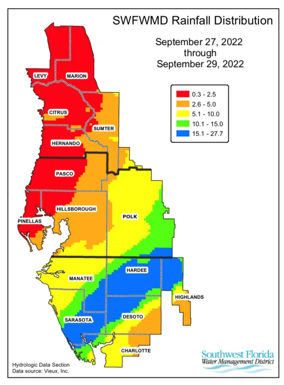
First, a few bits of data. The image on the right is the plot of winds across Florida, and the image below it is a plot of rainfall across the Southwest Florida Water Management District (SWFWMD) region. What you can tell from these is that we had hurricane-force winds and between 5 and 15 inches of rainfall across our watershed, associated with Ian. We did not, however, have any appreciable storm surge. And the winds we had, while stronger in southern Sarasota County than elsewhere in our watershed, were not as strong as what was seen in Charlotte Harbor both in 2004 and in Charlotte and Lee counties with Ian. We certainly have had wind damage, but not the widespread defoliation of the landscape we’d seen back in 2004, or what happened further south with Ian.
In our lower bay, we have had so much runoff into the bay that the surface waters are mostly low-salinity and high-tannin waters, such as what is often seen in the Lower Peace River. As we communicated last time, the water looks like root beer in much of the lower bay. That freshwater acts as a lens that isolates the saltier water beneath it, and it was not uncommon to find depressed levels of dissolved oxygen in the bottom water of Blackburn, Little Sarasota and Roberts Bays. But…the surface water had enough oxygen to keep fish alive, if they could handle the lowered salinity. We are going out there again tomorrow, but we saw no evidence – at all – of massive fish kills due to low oxygen last week. It’s a great time to see dolphins right now – saw about a dozen Sunday, and we saw many of them last week as well. That’s a good sign.
Earlier this afternoon, we got our bacteria values back from last week’s sampling, and although they exceeded relevant criteria in Blackburn Bay and the farthest southern portion of Little Sarasota Bay, they were not excessively high – compared to what we found in the Peace River in 2004. And in central and upper Little Sarasota Bay and Roberts Bay, the bacteria levels were in compliance with state criteria.
So far, this looks like fairly good news for Sarasota Bay.
However…our colleague at SWFWMD (Dr. Chris Anastasiou) has been tracking satellite imagery of the Gulf of Mexico, which leads us to the image below.
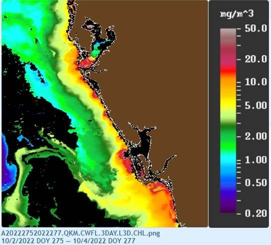
In this third graphic, the areas showing up as red are areas where there appears to be a phytoplankton bloom. We don’t know for certain, and in past years the satellite has had a hard time differentiating between high tannin levels and algal blooms, but the potential is there that this storm has loaded nutrients out into the Gulf of Mexico in such a manner that we may be in the early stages of a massive algal bloom in the Gulf of Mexico, due to the combination of rainfall, all the wastewater overflows we’ve had (more than 18 million gallons in our two counties) and the urbanized nature of runoff that is generated in our watersheds.
We may have good news for the bay over the next few weeks, but it could be that we’ve primed the Gulf of Mexico with enough nutrients to give us a massive algal bloom out there. What helps is that the water cooled dramatically after the passage of Ian. However, Ian also caused an upwelling of deeper water that has a natural nutrient content higher than most surface waters. Those will likely offset each other to some degree, with the extent of any possible future algal bloom in the balance.
We’ll keep you posted on what we find. But this is another reason why taking care of our watershed nutrient loads matter – because an offshore bloom might not stay offshore.