Sarasota County and SWFWMD Groundwater Study to Fill Gaps in Water Quality Knowledge
January 26, 2021
Darcy Young, Director of Planning and Communications
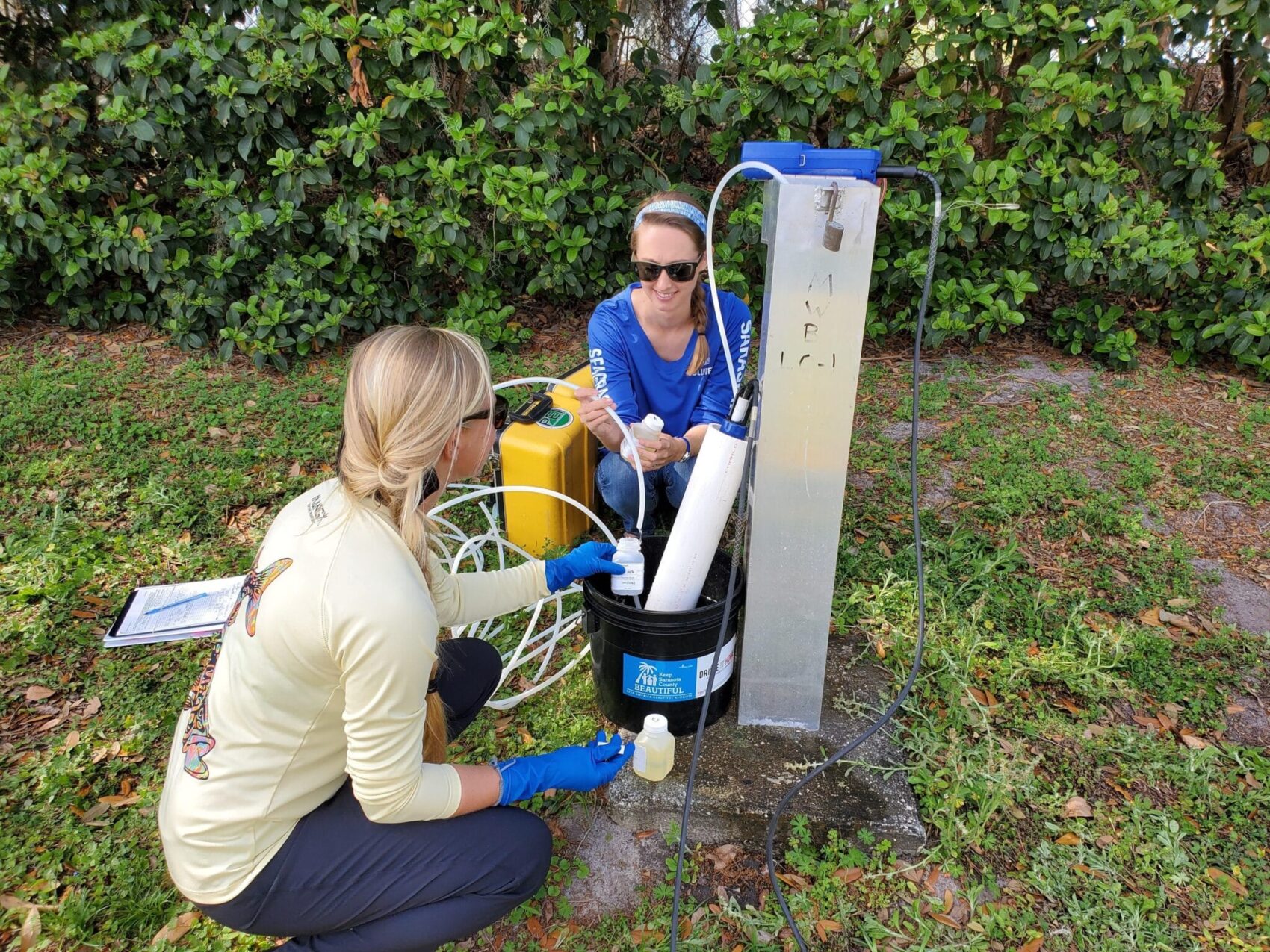
Sarasota County Public Works staff sampling a groundwater monitoring well. Credit: Sarasota County
Most Floridians know that water surrounds us, from the Atlantic Ocean to the Gulf of Mexico to our smallest neighborhood retention ponds. Yet the feeling of solid ground beneath our feet often blinds us to the water lying underground. That groundwater may hold keys to better understanding important connections between land and sea. Sarasota County and the Southwest Florida Water Management District (SWFWMD) will embark on a project this year to study how groundwater travels through different landscapes in Sarasota County and what it may be bringing along with it as it flows toward Sarasota Bay.
Simply put, groundwater is water found underground in the spaces between sand, soil, and rock. Dig a hole in your southwest Florida backyard and before long, you’ll hit water. That’s the area scientists call the “water table.” It sits closer to the surface in some areas, like freshwater marshes, than in many dry areas of the western United States. The U.S. Geological Survey estimates that there is over a thousand times more water in the ground than there is in all the world’s rivers and lakes. About 51% of the U.S. population relies on groundwater for drinking water. The Floridan aquifer system alone supplies drinking water for nearly 10 million people in Florida and Georgia.
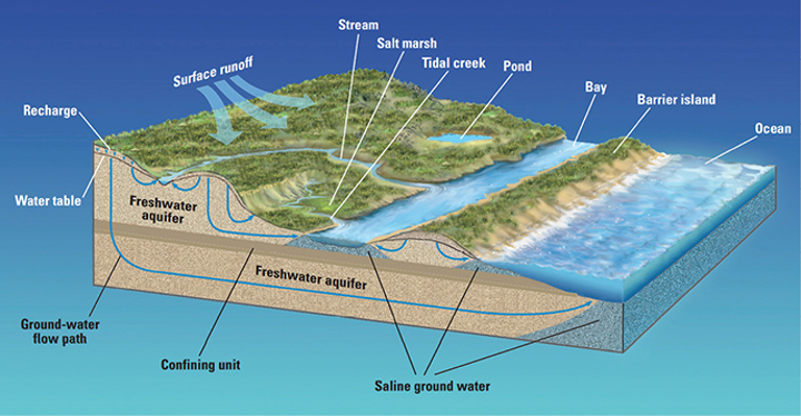
Credit: USGS
Like stormwater, groundwater recharge absorbs fertilizers, pesticides, pet waste, septic tank leachate, gasoline, and other pollutants from the land surface. To some extent, plants and soil filter out these contaminants. Groundwater flow is also very slow, which allows time for pollutants to slowly adsorb to soils and rocks underground. The direction and speed of groundwater flow depends on the characteristics of subsurface rocks. If subsurface rock is relatively permeable and porous, like Swiss cheese, then water may move through it more quickly. More dense rock leads to slower rates of flow. Impenetrable layers may completely force groundwater to flow in one direction over another.
Sarasota County’s subsurface geology has an impenetrable feature called the Venice Clay Layer. It lies only about 30 feet underground, creating an impenetrable boundary that groundwater can’t easily flow through. Between the Venice Clay Layer and the force of gravity, groundwater in the surficial aquifer can only flow west toward estuaries and the Gulf of Mexico. This means that there is likely a high rate of baseflow, or groundwater discharge, into creeks, bays, and the Gulf. Yet we know relatively little about this groundwater. Scientists and managers hypothesize that studying groundwater might help us answer some of the most pressing questions about Sarasota Bay.
Excess nitrogen in Sarasota Bay can lead to blooms of algae that can negatively impact seagrass meadows. The main question facing the Sarasota Bay Estuary Program and our partners is how best to reduce the amount of nitrogen reaching Sarasota Bay. There are four main pathways for nitrogen to reach Sarasota Bay: stormwater, point sources like wastewater discharges, groundwater seepage, and atmospheric deposition from burning fossil fuels. They’re four pieces of a pie that makes up the majority of nitrogen reaching Sarasota Bay. What we don’t know is the relative sizes of those pieces of pie – which pathway contributes the most nitrogen to the bay. We also don’t know which piece of pie is the easiest or most cost-effective to trim down.
This year, Sarasota County and the Southwest Florida Water Management District will begin a $300,000 study to dig deeper into three basic questions about Sarasota’s groundwater. First, does groundwater discharge to Sarasota County bays significantly contribute to the overall amount of nitrogen reaching Sarasota Bay? Second, if so, what kinds of landscape characteristics, like septic systems or fertilizer use, contribute most to the nutrients in groundwater? Third, what are the best ways to reduce the amount of nitrogen reaching the bay? The study will quantify nitrogen reduction methods for groundwater, such as advanced septic systems, and compare their cost-effectiveness to familiar methods for reducing nitrogen amounts from stormwater, like filtration systems and outreach campaigns to reduce fertilizer use.
Protecting Clean Water
“Through thick and thin the people of Sarasota County have always supported projects that ensure clean water for our beautiful bays and beaches. Our job is to find the least expensive way to fulfill their wishes. This groundwater study is an entirely new approach and the results will undoubtedly help us to find the best water improvement projects.” – John Ryan, Environmental Manager, Sarasota County Public Works, Stormwater Environmental Utility
Teresa VanderWaag, Environmental Specialist for Sarasota County Public Works and project manager for the groundwater study, has already begun sampling local groundwater monitoring wells that are in potential nitrogen hot spots, such as areas with high rates of fertilizer application and golf courses. With the results of this study, water quality managers will be better equipped to make decisions about protecting and restoring Sarasota Bay.