King Tides
What Are King Tides?
King tides refer to the extreme high and low tides that occur when the moon, earth, and sun are aligned and when the moon is closest to the earth in its orbit.
How Do We Get King Tides?
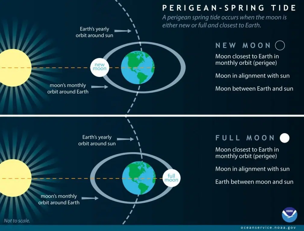
King tides are scientifically known as perigean spring tides, and as the name suggests, they occur when perigean tides coincide with spring tides.
SPRING TIDE + PERIGEAN TIDE = KING TIDE
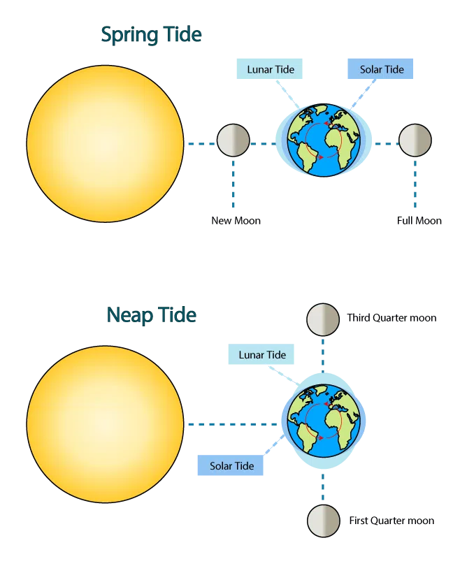
Spring Tide: the sun, moon, & earth line up
Both the sun and the moon influence the earth’s tides. The sun’s gravitational pull is about half as strong as the moon’s, so it ends up adding to or reducing the moon’s influence. For example, when the sun, moon, and earth are all aligned, during a full moon or a new moon, the sun has an additive effect that causes extreme high tides and extreme low tides. These are known as spring tides.
When the moon, earth, and sun are at a right angle, the sun’s pull in one direction slightly cancels out the moon’s pull in the other direction. This results in more moderate tides, also known as neap tides.
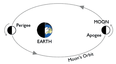
Perigean Tide: Moon’s closest position to Earth
Similar to the Earth, the moon also travels in an elliptical shape. Once every 28 days, the moon reaches its closest point to the Earth, or its perigee. When this happens, the gravitational pull is stronger causing higher high tides and lower low tides.
Perigean Spring Tide (aka king tide): The sun, earth, and moon are aligned & the moon is in its closest position to the earth.
Every once in a while, the alignment of the sun, moon, and Earth coincides with the moon’s closest orbital position to the Earth resulting in perigean spring tides. These extreme high and low tides are often targeted for king tide events around the world to help the public visualize and learn about future coastal flooding from climate impacts.
When Do King Tides Happen?
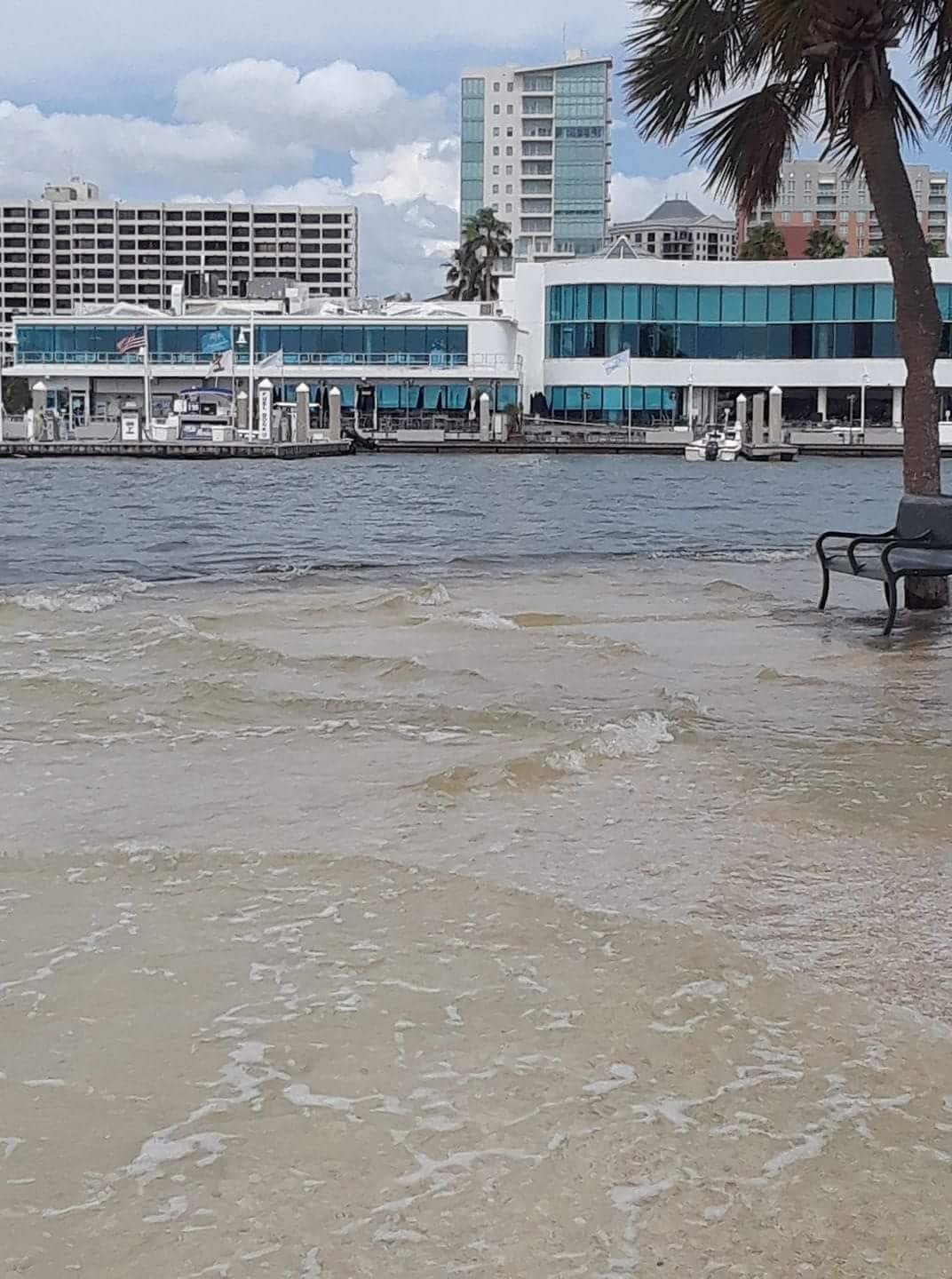
King tides can happen several times per year based on the orbit of the earth and moon. However, it's important to note that not all king tides look the same from a water level or flooding standpoint. Factors like storms or wind can also affect how much water may be present at any given location. For example, the photo below shows a king tide that coincided with Hurricane Nate in 2017. In this case, the events compounded each other and water levels overtopped the seawall at Bayfront Park in downtown Sarasota. On the other end of the spectrum, some events can lessen the high water effects of king tides. For example, if there is a king tide that coincides with strong winds blowing out of the east and pushing water offshore into the Gulf, we may not see flooding in hot spot areas.
2024 Expected Higher Water Events (Sarasota, FL)
- May 8 - 11, highest predicted tide: May 9 & 10 at 2.58ft
- June 5 - 8, highest predicted tide: June 7 at 2.63ft
- June 21 - 25, highest predicted tide: June 23 at 2.67ft
- July 3 - 7, highest predicted tide: July 5 at 2.59ft
- July 19 - 23, highest predicted tide: July 22 at 2.73ft
- Aug 16 - 21, highest predicted tide: Aug 19 at 2.75ft
- Sept 15 - 17, highest predicted tide: Sept 16 at 2.62ft
- Oct 19 - 22, highest predicted tide: Oct 20 at 2.70ft
- Nov 15 - 19, highest predicted tide: Nov 16 at 2.65ft
Documenting King Tides
King tides give us a preview of how and where sea level rise might affect local landscapes, which is important for anticipating and addressing “hot spots” for flooding and salt water inundation. In addition, documenting these effects helps ground-truth local sea level rise models and predictions.
King Tides Photo Contest: SBEP hosts a king tides photo contest for citizen scientists to submit their best high and low tide photos during a king tide event. Winners receive prizes! Stay tuned for opportunities to participate!
Contribute to King Tides Photo Databases: Whether you are taking photos for a contest or just capturing a shot on your own, you can still contribute to larger king tides photo archives.
King Tides Project - an international initiative to capture data and images from around the world to show what future sea levels will be and what is at risk. To enter your photos, just post them to social media with the hashtag #kingtides.
Florida Tide Watch - a collaborative project led by the Tampa Bay Estuary Program to document king tides on the Gulf Coast.
To learn more about king tides and other initiatives visit, EPA: King Tides and Climate Change.