Director’s Note: Tropical Storm Nicole
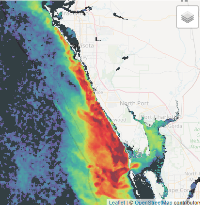
This week should be an interesting one for Sarasota Bay. Right now, we have an algal bloom (mostly offshore) that extends from Anna Maria Island down to Sanibel. The figure below is a composite of multiple days of satellite imagery, up to yesterday. The areas of yellow to red are areas that are experiencing an algal bloom of some sort. Sarasota Bay is about 50 square miles in size, and Charlotte Harbor is about 270 square miles. So, as you can see, the area of orange and red appears to be roughly similar to (if not larger than) the area of Charlotte Harbor. We can safely conclude that the algal bloom offshore of our coast likely exceeds about 200 square miles in size. This does not necessarily mean that the entire area is a red tide bloom, but the Florida Fish and Wildlife Conservation Commission (FFWCC) has recently sampled along our coast, and found red tide at “medium” levels over the last week in Blackburn Bay and inside of New Pass. Farther south, medium to high levels have been found in Lemon Bay, offshore of Manasota Key, and in Placida Harbor and Gasparilla Sound.
This brings up a topic worth touching on – can’t we just “treat” red tide when it’s out there threatening our water quality, our wildlife and our economy? Well, there are things that can be done that can help to mitigate red tide – we’ve known that for decades. But what do you do when you have a 200 square mile red tide? Consider this - the bombing raid against Dresden in 1945 involved more than 1,000 bombers from the United States Army Air Forces (USAAF) and the Royal Air Force (RAF) and destroyed an area about two and a half square miles in size. With that in mind, what would it take to mobilize enough crop dusters or such to “treat” a 200 square mile red tide? Until that scalability issue gets worked out, our focus will continue to be on not making red tides worse via nutrient enrichment from wastewater and stormwater, rather than trying to eliminate these events after they’ve grown fat and happy from the excess nitrogen we load into our local waters.
Also this week, Tropical Storm Nicole is expected to make its presence known, starting tomorrow. Wednesday into Thursday, we could be experiencing tropical storm conditions, with winds likely peaking around 30 knots (ca. 35 mph). A trick that sailors know is that as you get closer to a low-pressure system (which is what tropical storms and hurricanes are) or as it gets closer to you, the wind will “back – which means the direction from which the wind comes from will move counter-clockwise. That means our stronger winds should first come from the NE, then NNE, then North as the storm gets closer, which will be good for us, as it could help to push this red tide farther away from our coast, and thus farther away from the mass of nutrient-laden runoff that was delivered to the eastern Gulf of Mexico after Ian.
However, the winds will continue to back as the storm gets closer, and Thursday’s forecast (as of today) is for strong winds (20 to 25 mph) out of the Southwest, accompanied by 4-to-5-foot waves offshore. That should help to push water masses towards our coast at the end of the week. Early estimates are that Nicole might produce anywhere from 2 to perhaps as high as 10 inches of rainfall over our watershed.
To be sure – this will NOT be as impactful as Ian, in terms of rain and wind. But it could actually cause more beach erosion, as Thursday we might have > 20 knot winds and four-to-five-foot waves out of the Southwest, which would be much more damaging than the winds out of the East and Northeast that Ian brought us. Thursday, before 2 AM, we will be having a very high tide (2.7’ estimated above Mean Lower Low Water - MLLW) due to a nearly full moon. If that high tide matches up with strong winds out of the Southwest, that could push an awful lot of water onto our beaches and into our bays. I’m personally prepping my boat for the potential of perhaps 4 feet above sea level Thursday morning (early morning) due to the potential combination of strong winds, a wide fetch (distance across water for wind to blow), a high tide, and the moon phase.
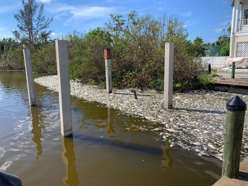
That could push a lot of water into our bay, which might not be a lot of fun if the preceding days of wind don’t disperse the existing red tide, or if rainfall feeds more nutrients to that red tide. We already have red tide at levels high enough to cause fish kills in Lemon Bay (see below photo) which could be what we will be seeing as well, should this red tide worsen and push into our bays.
There’s not a lot we can do at this point in time, other than to continue to push for actions that reduce our adverse impacts to water quality from stormwater and wastewater, to get more filter feeders into the bay (our CCMP goal is to have 10-acres of “new” oyster reef over the next 5 years) and to preserve and protect our mangrove shorelines more effectively. The tannins that leach out from decomposing mangrove leaves help to keep harmful algal blooms under control – remember that the next time you have a red tide lapping up against a bare seawall. We can do better, and not everything that needs to be done has to be a big government-led project. Treating mangrove shorelines with more respect doesn’t cost any money – it’s simply requires making a decision about whether or not we want to make our bay more resilient – or not. The choice is ours.
Stay safe!